|

|
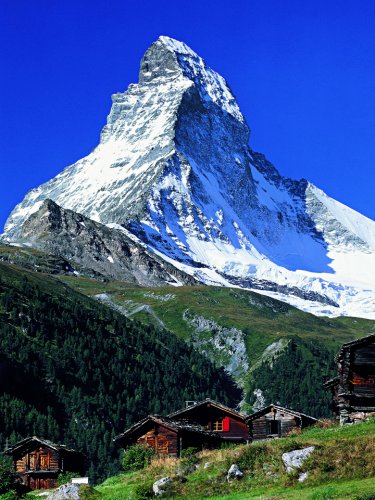
The "Matterhorn" is one of the world's most famous mountain. It rises 4478 meters high, but is not the highest mountain in Switzerland (see mountains for more details). The first men who managed to climb to the top of this mountain was a group of seven mountaineers led by Edward Whymper from Great Britain on July 14, 1865. Four of the seven men died on the way back. It is unknown who named this mountain "Matterhorn" or where the name comes from, but there are many families in this valley named "Matter". From a climate point of view, Switzerland is located in a transition zone. In the west, there is a strong influence of the Atlantic ocean. Winds bring a lot of moisture into Switzerland and cause rainfall. In the east, there is an almost continental climate, with lower temperatures and less precipitation. On the other hand, the alps - which run from east to west - act as a climatic divide. South of the alps, there is an almost Mediterranean climate, with significantly higher temperatures but also a lot of precipitation. Generally speaking, spring is wet and cool, April is well known for fast and often changing weather conditions. Summer is supposed to be warm and dry with maximum temperature up to 35°C (95°F). The temperature depends primarily on the elevation, the zero line (0°C or 32°F) may raise as high as 4000 meters above sea level (13125 feet). Fall is usually dry, but cool. The temperature will drop significantly in September or October, with the zero line around 2000 meter above sea level (6560 feet). Winter is supposed to be cold and dry. The temperature may drop below 0°C everywhere in Switzerland, especially at night. In the alps, they usually get a lot of snow, but even at lower elevations, there is a good chance that they will get a foot of snow every now and then. See Climate in Switzerland for much more detailed information and links to weather forecast services. 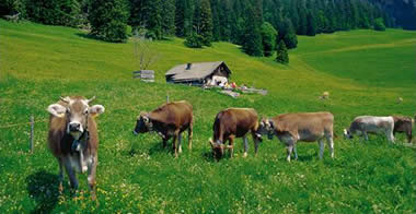
Switzerland is the pioneer of bio-agriculture and of keeping livestock in appropriate conditions. Over thirty years ago the foundations for the development of bio agriculture were laid. Its objectives were the sustainable use of natural resources, the protection of the environment and of animals and the production of healthy food. Today Switzerland has the highest per capita consumption of bio products in the world; 11.2% of all farms and 10.5% of all agricultural land are devoted to bio agriculture. Bio agriculture is strongest in the alpine regions. In the Canton Graubünden 51.8% of agricultural land is used for bio products. The geography of Switzerland is notable for its great diversity. Switzerlands three main geographical regions are the Jura, Plateau and the Alps. Switzerland has a high population density, with 234 people per square km (606 per square mile) of the productive area in 2000. In the agglomerations, which cover about 20% of the total surface area, the density is 590 per square km (1528 per square mile). ?The geography of Switzerland means that the climate varies greatly from one region to another. Depending on the area and the time of year, Switzerland experiences conditions reminiscent both of Siberia and of the Mediterranean. At the heart of Europe It is often said that Switzerland lies at the heart of Europe. Geographically speaking, that's not quite true. However, the main route linking northern and southern Europe does run through the Alps. The total length of the frontier is 1881 km (1168 miles). Switzerland borders Germany in the north, Austria and the Principality of Liechtenstein in the east, Italy in the south and France in the west. This means that three important European cultures meet in Switzerland - that of the German-speaking area, the French and the Italian. Size, regions, population Switzerland has an area of 41,285 square kilometres (15,940 square miles). The productive area - that is, the area without the lakes, rivers, unproductive vegetation and no vegetation at all - covers 30,753 square km (11,870 square miles). 7.4 million people- just over one thousandth (0.1 per cent) of the global population - live in Switzerland. Type of state There are about 30 countries in the world with a federal structure. Switzerland is the smallest federal state. However, its 26 cantons and four different languages make it one of the most complex. Short distances Switzerland measures 220 kilometers (137 miles) from north to south; this takes four hours to travel by train and three hours by car. It's 350 km (217 miles) from east to west. On a journey of 3 to 4 hours the official language can change two, three or even four times A lot in a small space There isn't anything in Switzerland that you can't find somewhere else in the world. Finland has more lakes, the glaciers in Iceland are bigger, the mountains in Nepal are higher, in Italy you'll find more apricot orchards. But in Switzerland all of this is so close together. On a 2 to 3-hour train trip you can see completely different landscapes. Seasons The seasons are clearly defined. In spring (March to May) the trees blossom and the meadows become green. In summer the temperature rises to 25-30 degrees (77-86 degrees Fahrenheit). In autumn (September to November) the fruits ripen, then the leaves turn brown and fall. In winter the snow changes the landscape. Contrasts The lowest point is Ascona, in Canton Ticino, only 196 meters (643 feet) above sea level. Here, palm trees grow and the climate is Mediterranean. The highest point is the Dufour Peak, in Canton Valais, at 4,634 meters (15,199 feet), with an arctic climate. As the crow flies, Ascona and Dufour Peak are 70 km (43 miles) apart. Mountain and valley Valais in the south is a mountainous canton, famous for the Matterhorn and Switzerland's longest glacier, the 23 km (14 miles) long Aletsch. Yet apricots, cherries, tomatoes and grapes grow in its valleys. Damp and dry Stalden in Valais has as little rain as the steppes, 52 centimeters (20 inches) per year. Forty km (25 miles) away, the peaks around Monte Rosa receive some 400 centimeters (156 inches) of rainfall. Small and complex The southeast canton of Graubünden covers 7,100 km2 (2,741 square miles) and contains 150 valleys. Its rivers flow into three different seas: the North Sea, the Black Sea and the Mediterranean. It has a population of only 186,000, yet between them they speak three of the national languages. Transit Switzerland stands on the route linking northern and southern Europe, but the Alps made transit difficult until tunnels were built through them. The Gotthard railway tunnel, 15 km (9.3 miles) long, was built more than 100 years ago. The Gotthard road tunnel, opened in 1980, was the longest in the world at 16.5 km (10 miles) until Norway's Laerdal tunnel (24.5 km/15 miles) opened in November 2000. 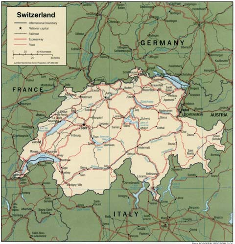
|
| ^ Back to Top | Home | History | Tourism | Cities | Culture | Geography | Music | Animals & Plants | Imports | Links |
Team Swiss